Support

Webinars

In case you didn’t catch our recent webinars, here they are!

Tutorials

We’re here to help! If you have any questions, feedback, or need assistance, feel free to reach out.

📧 Email Us
Send us an email at info@geoforager.com, and we’ll get back to you as soon as possible. You may also call us at (970) 930-1882.
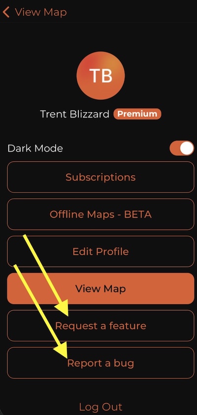
 Screenshot of Request a Feature or report a bug

Report Bug
Use your Account screen, inside of the app or browser to report a bug – it sends us lots of good details to help us solve the problem. (see screenshot to right)

Request a Feature
Use your Account screen, inside of the app or browser to Request a Feature (see screenshot to right)

Below you’ll find a quick overview of many of the map features. Click play on a video and then click the [ ] at bottom right to view at full size!

How to Save Offline Maps
Understanding the Tracking Function: A Step-by-Step Guide
Managing Markers and Folders Effectively

Updates

10/27 – Ver 1.3.2 – Added Marker Waypoints, Photos & Folders & Photos
11/15 – Ver 1.3.3 – Upgraded login process to work better offline
11/20 – ver 1.4.1 – Added Current Elevation to on-click of My Location icon
12/01ver 1.4.2 – Added Tracks
1/20/26 ver 2.1.0 added search, added snowdepth to on-click data
1/28/26 ver 2.1.4 – Added 8 more tree species, made on-click a 500ms hold to activate
2/1/26 ver 2.2.0 – Added 2025 wildfires, 2026 morel probability & burn severity
2/13/26 ver 3.0 – added offline layers (public land), increased online zoom level
2/20/26 ver 3.0.2 – Added a new overlay “offline map outlines” that shows all offline maps on the mainmap; added new tree types map with 142 tree types; made offline maps “editable” so new layers can be added to an existing off line map save.

2/22/26 Added Logging maps from 2025.