How to Find Burn Morels – Terrain Based Predictions

The 2022 burn morel season is shaping up to be as good or better than any season in the last 5 years. The 2021 fires that guide our hunts were unusually widespread from Southern California up through Oregon, Washington, Idaho and Montana with each state having at least 10 excellent high-potential fires. These huge and widespread fires will offer abundance and a problem: where to start? With millions and millions of acres burned, the biggest challenge for many morel hunters will be where to start? Which fire? And which area in which fire?

As everyone knows, there are many maps out there that will show casual pickers where the burn perimeters are located. But they don’t really solve that primal problem of which fire to start with and where in the fire to focus your attentions. Of course at Modern Forager, this is what we do.

Get Burn Morel Maps >

This year we are rolling out several new maps to help pickers. We plan on releasing new features every week or so as we build them. Some of our maps, like the tree maps, are for expert pickers who want to locate specific tree types inside burns. This week we have an exciting new map concept for beginners and are really curious what you think: Prediction Maps.

NEW MAP FEATURE! Terrain Based Morel Prediction Maps

Our new terrain based Morel Prediction Maps use an algorithm to rate areas within each fire (in 30 meter sections) based on ideal terrain features and then color score the map. Bright yellow is best and equates to a burn morel “hot spot” – an area where we predict the morels will flourish.

Here is an example from the Big Hamlin fire in Oregon (a 19,000 acre fire – huge!):

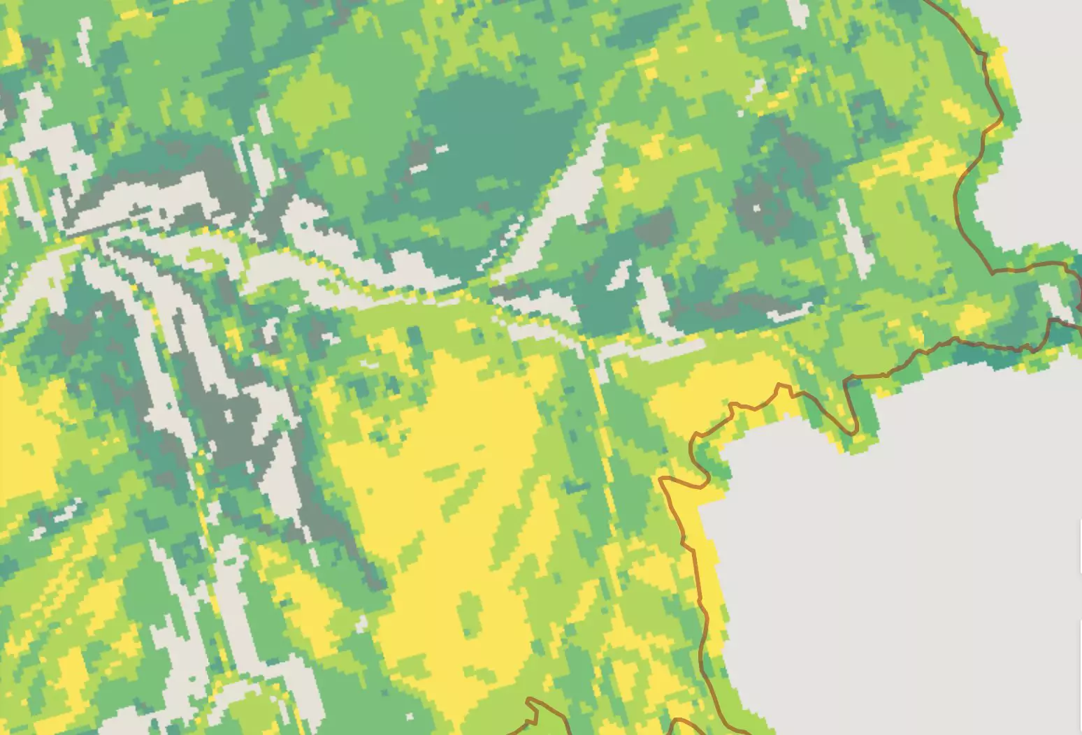
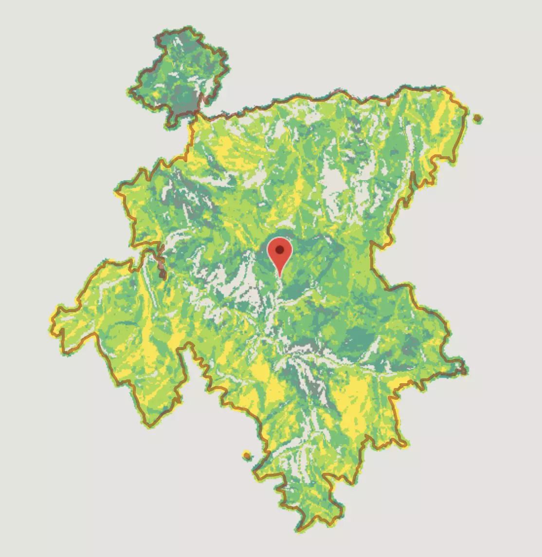
Above Map: Morel Prediction Map from the Big Hamlin fire in Oregon from 2021. Bright yellow and yellow/green are the best, the lightest gray (appearing almost transparent in the map) is to be avoided entirely, and dark green/blue/gray is mediocre at best. We put a lot of thought into what went into these maps. Predictions are composed of three primary terrain features:
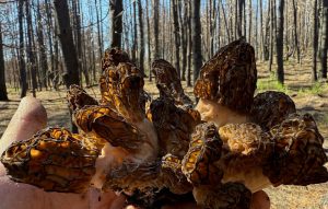
  1. Tree Cover Density: We rated the tree cover on a scale of 0-3. Heavy tree cover is a positive.
  2. Slope: For general public accessibility, we rated any slope over 30% as zero. We especially like to find large areas of slope less than 15% for easy picking. Make no mistake though, morels don’t mind slope! But steep slopes are exhausting and dangerous for picking. Generally we avoid them if possible.
  3. Aspect: We rated anything with a North or Northerly aspect as high likelihood. Southern aspects got no points. East or West were rated as middling. This rating was the most discussed, since clearly all aspects produce when the weather is ideal. However in our experience, on an average picking day with average weather patterns seen in the West, Northerly slopes far outproduce.
There is more terrain data to uncover and bake into the maps. Our intention is to include these data points in the maps we will be releasing throughout March. Stay tuned for the maps to include:
  • Elevation; While we definitely favor certain elevation ranges, the desired elevation range has variables like season, species/flush and location. For example, 6000 feet is too low in the Colorado Rockies, but, too high in Oregon for anything but July picking.
  • Tree Species: The desired tree species change from region to region and are key to advanced pickers. For example, Douglas Fir may be very desirable in Arizona but less exciting in Oregon.
  • Burn Severity: I almost included this in the algorithm. However, while burn severity maps are highly useful, the data is not as reliable. Cloud cover can contaminate the results. I didn’t want to mess up the calculations. I will release burn severity maps separately next week.
Let’s look at some closeups. This map below is a zoomed in section of Big Hamlin. The color gradations are a bit easier to see:

The large yellow spot really stood out in our algorithm. Plus there is a lot of other bright yellow nearby and lots of surrounding pale green, which will also be pretty good.

When you compare it to the satellite picture, you can see that the heavy trees and good picking areas really line up well.

Normally we spend a lot of time studying the topo map, looking for areas that have the slopes and aspects we want. We look for slopes where the topography lines are spaced far apart. Aspects take more studying because Northerly and Southerly aspects are hard to tell apart without finding elevation markers. Clearly, the bright yellow areas on our prediction map are relatively flat for easy picking and also Northerly facing. This USFS topo map remains a big help to because it shows a lot of detail about access roads. A big warning to people using free maps – Google maps do not have this level of road detail.

We’ve taken big steps this year to add even more value into our burn morel hunting maps! We have a team of GIS experts pouring through the fire data so that we can set you up for success finding burn morels. Stay tuned each week for new and exciting things to come. 

Get Burn Morel Maps >

So what do you think? Let us know in the comments below.

More From GeoForager

Contact Info

About

Leave a Comment

Your email address will not be published. Required fields are marked *