Williams Mine Fire Burn Morel Overview
Washington’s Williams Mine fire is 1,300 acres and will be a popular destination this spring and summer for burn morel hunters. Conveniently located on the Southern slopes of Mt. Adams and North of Trout Lake, it offers easy access from Portland and Seattle. I grabbed the coordinates of the fire and used Google maps to show travel times:


I’ll be using the GeoForager burn morel hunting maps below to provide an overview and tips about hunting this fire! All imagery was captured directly from the system. If you have any question about the maps please feel free to reach out to me at info@geoforager.com. Free trials are available on the website here. This will give you a good overview of the system using 3 year old fires – you can decide if it works for you or not before purchasing!
Public Land
The northern 1/3 of the fire is in the Mt Adams Wilderness, where mushroom picking is against the law. The fire is also in the Gifford Pinchot National Forest were you can harvest 2 gallons a day with a free permit online (which is quite unusual, kudos to Gifford Pinchot). Visit their website to learn more about commercial permits.

We also have a Public Access map (see in screenshot above) which shows that the rest of the fire is on public land (Gifford Pinchot National Forest) – this is the spot I’ll be targeting.
Elevation
This fire has an elevation range of 2,945 ft to 6,095 feet, with a Southern aspect. The Southern aspect means it will fruit earlier because of warming spring sun, but can also dry out faster if April and May rains don’t come. We could find ourselves in the 3,500 – 4,500 during May. I use the elevation finder to show this zone inside this fire, just to get a sense of the location. In April we normally would visit elevations below the red side of the gradient. However with April only a few weeks away, this burn is still covered in feet of snow (see below under heading Moisture and Precipitation) which means it may not be ready in April. In June we go higher, above the blue side of the gradient, keeping in mind that the upper part is mostly Mt Adams Wilderness – but not all!

You can also see creeks in the map running downhill from the North. Depending on how dry it is, you could also focus on the creeks that deliver run-off from above and offer east and west facing slopes, aka, microclimates.
Morel Probability
Our morel probability map uses trees, canopy, slope and aspect to help you find the best places to hunt. We score Southern aspects lower because they tend to dry out faster and be less productive. This fire has a lot of green, which is excellent – because it is monolithically Southern facing, it has very little high-probability yellow zones. As mentioned above, it will likely go a bit early and need moisture to produce!

The morel probability map does not factor in burn severity (below). Notice how the probability scores diminish in the upper 1/3 of the fire… why is that? see below.
Burn Severity
Another big consideration it the severity off the burn. In many cases, the most severe burn (purple below) and high severity (red below) areas of the burn are less productive for burn morels – but not always! In the burn severity maps, green through Orange zones are where we usually start and ultimately where we find the most mushrooms 80% of the time. Burn morels prefer areas with shade and duff – they hold moisture much better.

Forest & Trees
Tree Density
As we focus in on this burn, we start looking at the trees – its always about the trees! In the satellite view you can see immediately that the Northern portion (which is Wilderness) is mostly devoid of trees. That is why this area of the fire scored so poorly in the morel probability overview above.

Forest Type
Forest type is a “broad” indicator that speaks to the character of the overall forest. This fire has two types: Fir/Spruce/Mountain Hemlock in the higher elevations and Douglas Fir Group in the lower elevations.
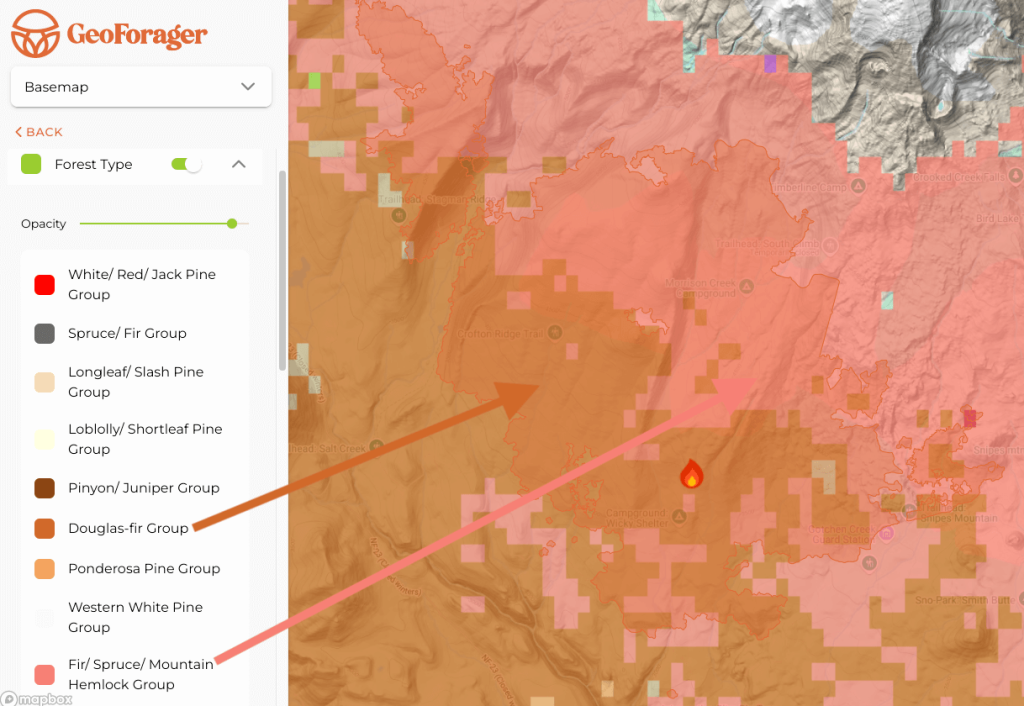
These two forest types can represent two different dominant zones. Realistically, you might find different species or flushes in the two different zones. This mixed zone habitat is usually a good sign. My favorite zone overall is the Fir/Spruce/Mountain Hemlock group but the Douglas Fir zone is good too. As a picker, you will want to visit both these zones and scout them independently. As an armchair researcher, this fire bodes well from the tree standpoint.
Tree Species
For the more advanced burn morel hunter, we also offer tree maps by species (coming very soon if not already). Click on the images below for full-size versions. Burn morels like all three of these tree species.


The maps also show some light cover of ponderosa pine and Lodgepole pine.
Access
Now that we know this fire could be good picking for all the reasons listed above, lets look at access. The fire has great access from several roads that you can see in the Motor Vehicle Use Map (MVUM) which is provided by the USFS. Also, topo maps show quite a few trails:


Worth noting in the MVUM map are not just the roads going into the main fire, but access into the Eastern and Western edges of the fire as well. They got a little cut off in my screenshot but offer lots of access along the edges of the fire. Likewise, there are many foot trails that provide logical ways into the fire. I liked all the creeks in this foot trail closeup in the screenshot above.
Moisture and Precipitation
It is a bit early to be watching the rain here (March 13th as I write this). However, as we get closer to the pick I will start to pay attention to the rain maps and look for spots that have gotten rain, ideally, once a week for the last 3 weeks. A big rain can really cause the mushrooms to pop if it is warm enough! However, if we go 4 weeks without rain prior to the first fruiting, morels may not ever really flush abundantly.
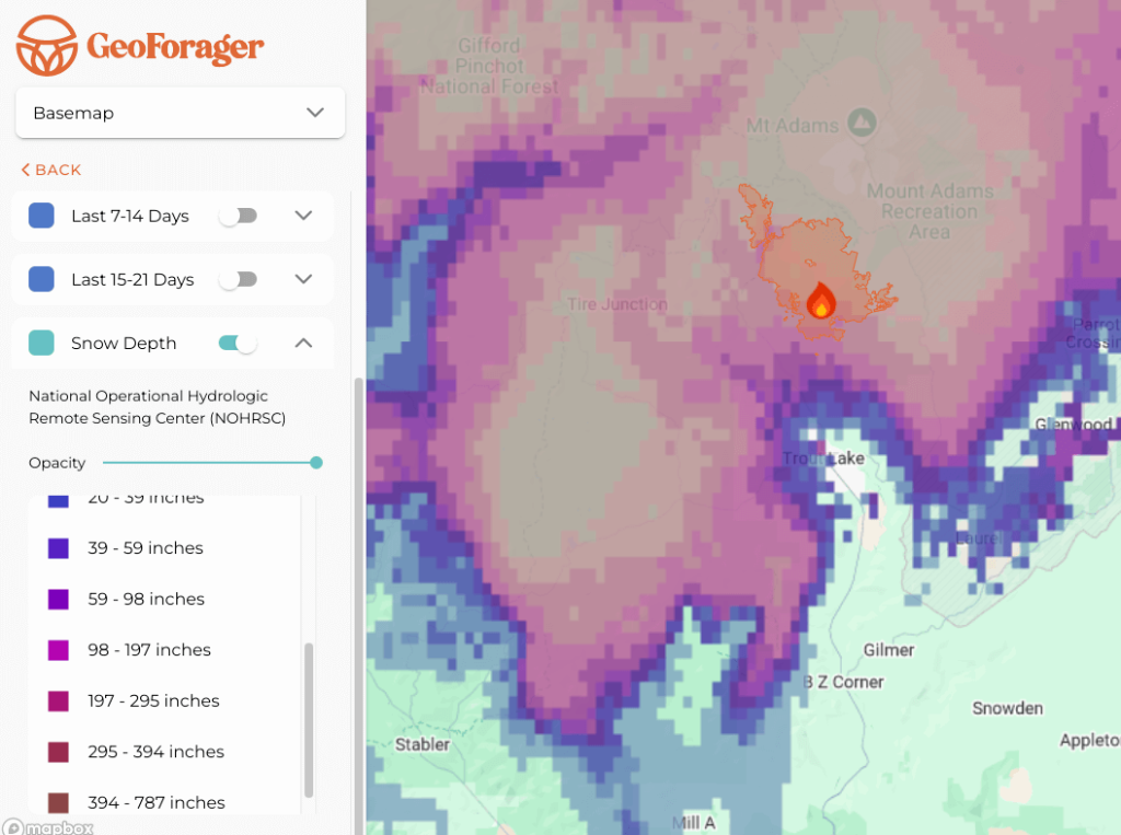
The burn is currently completely covered in large amounts of snow – 200+ inches! As the spring progresses, I’ll be watching this map to figure out when the burn morels will likely start – probably about a month after the snow melts in that spot. Of course it could be sooner or later! The good news is that this burn is covered in a lot of snow and is downhill of even more, setting it up for success in May and June.
How to Get There
The fire looks easy to approach from the south via Road #8040 which goes north and up into the fire, with lots of opportunities to explore east and west from the road with some trailheads and a campground up at the top of the pickable area. Many trails offer access into big sections of the fire.
Also, currently the fire is open per the USFS: the closure order on the fire was officially rescinded. So, as of writing, this is an OK fire to go visit.
The Williams Mine fire is highly accessible both to two major West coast population centers: Portland and Seattle. As such, I would not expect a lot of commercial pressure here, but lots of visitors from nearby will keep this fire hopping. With its Southern exposures, hitting the fire a few days after a good rain in May or June is probably the ticket!
Getting Into the Hunt
If you’ve ever thought about trying your hand at burn morel hunting, this could be the year! There are many, many good fires across the western states this year (and you can even find them in the East friends – we offer burn perimeters for the entire Continental US!). These mushrooms closely follow predictable indicators, can offer huge rewards (large caches quickly into your baskets), and are relatively easy to locate with this kind of in-depth research. Our maps do most of the heavy lifting for you! We are constantly improving them and adding new data layers. If you are curious, you can get a free trial that will give you an introduction to the interface. Or, you can jump in and get the full version. They are available on our website. You can now also download an app from iOS or Google Play for use on your phone. The easiest method to get your account setup is to first get the maps via our website, get your login setup and then go find and download the app and login with the credentials you created.
If you have questions, please feel free to reach out anytime – info@geoforager.com or (970) 930-1882.